Monday, April 22, 2024

Choosing the Best Sextant Sights

 The criteria for choosing best sights is outlined in the Star Finder Book and in the manual to the StarPilot programs, but this online course has shown us that we need more specific notes on this. Again, this is the type of thing we generally covered in the classroom lectures, so it had been only sparsely covered in the printed materials to date.

The goal of sight selection is always to optimize the accuracy of the fix. If only two sights are available, then these would be ideally about 90° apart in bearing so that intersection errors are minimized. This is the same criteria used in choosing targets for compass bearing fixes in pilotage waters. If instead of 90° apart, the two targets were only 10° apart, then any small error in either of the bearings would cause a large error in the intersection when the LOPs were plotted. 

Use any chart and plot a bearing fix to two objects that are 10° apart and then repeat the plot assuming one of the lines is wrong by 3°. Look at how much the fix changes. Then do the same thing for two objects that are 90° apart at about the same distance off. When they are 90° apart the error will be 5% of the distance to the nearest mark, or something near that. But for the two close bearings the error will be much larger.

For a two-sight fix, this "scissor effect" on the shift of the intersection is minimum at 90°, but from a practical point of view, any LOP intersection angle more than about 30° will reduce most of this error enhancement, and you really don't gain much going to intersection angles above 60° or so.

The same reasoning applies to cel nav fixes. First if you are limited to two sights, then they should be some 30 or more degrees apart... ideally closer to 60 or 90. And, as always, you should take at least 4 sights of each object if you can, alternating at least the first couple of them. The reason for alternating, is to cover the situation where you just get two sights then something happens. If these are two of the same body, you are left with only an LOP, but if of different bodies you have a fix. Not the best you might have gotten, but at least a fix. For the record, I have been on two vessels where my sight taking was interrupted early in the process, and in both cases, a cel fix at the time was crucial. In the first case, the boat under spinnaker in the ocean broached on a wave, which kept us busy with immediate sailing issues even more crucial than improving the quality of the fix. In the second case, a pressure cooker exploded below decks, and the first aid issues again took precedence over the navigation. Needless to say, both of these examples are rare cases, but the goal of sound navigation is to develop procedures that cover you even in unusual circumstances. 

Figure 1. When LOPs are closer than some 30° apart, the fix errors are greatly enhanced (red lines) due to unavoidable uncertainties in the bearing lines. Here the error shown is 3°.

Also in cel nav we have limits on altitudes. Generally you would choose sights above about 15° and below about 75°. This is for two separate reasons. Low sights, especially down within say 5° of the horizon are more influenced by refraction. Refraction is the one uncertainty we do not have much control over in cel nav. We routinely make refraction corrections, but we are always vulnerable to abnormal refraction. In other words, mirages do indeed exist, and some are very prominent from the water in some circumstances. Mirages are an impressive demonstration of the presence of abnormal refraction. In the open ocean, when there is no land or vessels over the horizon to see mysteriously floating above the horizon in a mirage, we have no way to know that abnormal refraction is present, so we have to just be vigilant. There are special tables in the Nautical Almanac for correcting for abnormal refraction based on temperature and pressure, but what is not stated in these tables is the fact that the uncertainty in these corrections are about as large as the corrections themselves. Indeed, we do not even include these in our routine procedures, unless you are forced to take low sights, in which case they probably statistically would be right more often than wrong. Sights within some 5° of the horizon might be off by as much as 5 miles or so, even with the special corrections. Not always, and maybe even not likely, but definitely possible.

The best bet is to just avoid low sights whenever possible. Refraction correction is about 35' on the horizon, then 10' at 5° and 5' at 10° and then it just gets smaller as the elevation (Hs) gets larger. Look at the altitude correction for stars, since that is pure refraction.

The reason for avoiding high sights is completely different. There are two reasons for avoiding high sights. One is they are harder to take because the bodies are nearly overhead, which makes it difficult to tell which way to point the sextant as you rock it. For high sights it is easy to be misled into thinking you have the body aligned with the horizon when you do not. Hence if you do get stuck and need to take very high sights, be aware of this issue when rocking the sextant.

The other problem with very high sights is the sight reduction process itself. For high sights the LOPs cannot be accurately approximated as straight lines (which is our normal procedure), since the the circle of position now has a relatively small radius. Later we will add a section on processing high sights, for now the issue is just to avoid them if possible. If you are eventually using the StarPilot for sight reduction, then this issue is taken care of automatically, but when sight reducing and plotting by hand, we need special procedures for sights above some 75°. It is not difficult, and does not require special tables or compuations, but it is different.

Summary so far: for two sights only, choose the two bodies as close to 90° apart as possible and find bodies that are above 15 and below 75 degrees in height, and then take 4 sights of each to average for the two best LOPs. Sight averaging is covered in the course book, chapter 11.

But... with all that said, two stars (even in the right elevation range) are not the best option in the first place. Three stars are much more valuable for an accurate fix. Even if you take multiple sights of the two bodies, which reduces your statistical errors from any one measurement, you still are left with just two LOPs, the average from each set. You do get a picture from the plot of the LOPs what this level of uncertainty is — the more they are spread out the more uncertain the fix is — but you do not learn anything about systematic, or constant errors that might apply to each sight.

That is the value of choosing 3 sights that are about 120° apart. In this configuration, any constant error in each sight simply makes the triangle of LOPs (called the "cocked hat") larger, but the center of the fix remains an accurate position. This is not the case with 3 sights that are 60° apart, even though the final cocked hat of intersections might look identical. As time permits, we will add numeric examples to illustrate this important point, for now, however, the main goal is to explain the rest of the criteria beyond the geometry.

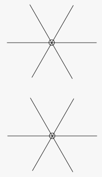
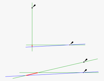
Figure 2. This is the way 3 LOPs would appear if there were no errors at all in the sights and they were reduced using the true position as the AP for each sight.

The top picture is for 3 sights taken 120° apart, the bottom is for 3 sights taken 60° apart. 

Assume that Hc = 30° 20' and Ho = 30° 20' for each sight

While the choice of geometry (selecting 3 bodies as near 120° apart as possible) will always be the dominant criteria in selecting bodies (along with above 15 and below 75° high), there are other criteria as well. The other factor is brightness. You can take more accurate sights of ones you can see clearly. So when all else is equal, or about equal, then choose the triad that includes 3 of the brightest stars. For example, if you have 3 stars that are very near 120 apart, but one of them is a magnitude 2.5 star, then you would almost certainly get a better fix from 3 that were, say, 130 and 110, 120 apart. In other words, you can tweak your choice to give up 10 or 20 degrees in optimum angle in exchange for brightness. There is a big difference in apparent brightness between a magnitude 2.3 star and a magnitude 1.5 star. See the table in the Star Finder book which coverts the magnitude scale to perceived brightness.


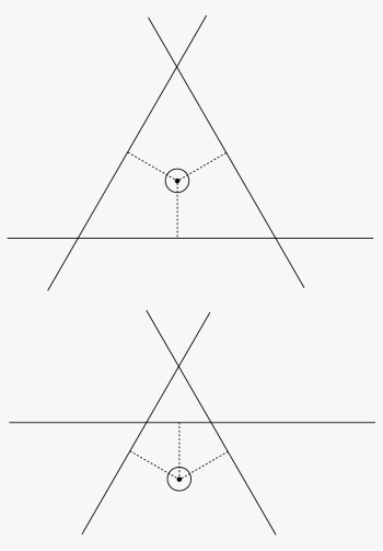
Figure 3. Now we show the same sights as above, but now assume there is a contstant 5' error in each sight, ie the sextant read 5' too high on each sight. We now have Hc = 30° 20' and Ho = 30° 25' for each sight, which gives a = 5' T 060, 180, and 300 for the top sights, taken 120° apart and a = 5' T 300, 000, 060 for the bottom sights taken 60° apart. They are all again reduced from the true position.

Note that the center of the top sights is still the proper fix, even with a constant 5' error, but in the bottom case, if we chose the center of the triangle as the fix, we would not get the right answer.

The main point is, we do not know what the error is, so we can't guess ahead of time where the fix should be for 3 sights 60° apart. We only know that the final uncertainty is larger than we would guess from the size of the "cocked hat" of intersections.

Once you have chosen several possible triads that have comparable quality on spacing and brightness, the final criteria would be to choose the triad that has the 3 stars at about the same height. This is again because of refraction. A star at 70° has a different refraction correction than one at 20° and if you happen to be in a case with abnormal refraction, you will magnify this effect by having stars at different heights. Again, the goal is to take advantage of the 120° geometry. If we have a refraction uncertainty, then to first approximation it will be the same error for all 3 stars if they are at about the same height. And if the error is the same for each sight, it will cancel out with the 120° geometry. We have of course removed the main effect of refraction by limiting all sights to above 15°, but this is now the third level of choice criteria, which is really fine tuning the process. The first filter kept our unknown errors below a 2 or 3', this final choice might help us get to the optimum accuracy of some 0.5' or so.... all providing we have taken into account the motion of the boat properly. 


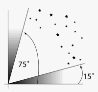
A graphic reminder that when we have a choice, we choose sights above 15° and below 75°. Naturally, if there are no other options, we take any sights we can and keep in mind the special issues of each region.

If you do not advance all sights properly, then you loose accuracy according to your speed and time in the sight process. If I am moving at 6 kts, and take 30 minutes to do my sights, then I have a 3 mile uncertainty floating around that will mask much of this fine tuning in star choice if I do not correct for it. This again, is a virtue of the StarPilot or other computer or calculator based sight reduction. All sight reductions automatically advance all sights to the time you ask for the fix.


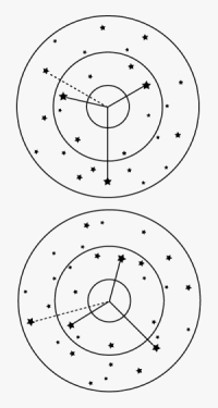
In the top picture, we give up a superior 120° spacing in favor of a brighter star that has fairly good spacing.

In the bottom picture, we sacrafice a bit of spacing for 3 stars at about the same altitude... or more to the point, to avoid one that is rather different than the other two.

All of these choices are fluid. The general criteria is discussed in the text, and from that you make your best choices and try options if you have the opportunity. Or take them all and do the fixes in various triad combinations to learn more of the practical matters.

For the record, in the StarPilot program, which is the only software available that actually sorts out and selects best sights from any sky, we use as a default weighted criteria: 70% on geometry, 20% on brightness, and 10% on relative altitudes, with Hc max = 75 and Hc min = 15. Each of these criteria can be adjusted by the user.

Friday, April 5, 2024

Role of the Safety Depth in ENC Display

When viewing an official electronic navigational chart (ENC), the user selects three depth contours (shallow, safety, and deep) and also sets one specific depth value called the safety depth. These four choices affect the colors of objects we see on the chart, as well determining several other features of the chart display.

The safety contour is the most important one as it separates what is called the safe water from the unsafe water. It will trigger alarms and it determines when isolated hazardous objects change from their normal symbol into the prominent isolated danger symbol, which is determined by the requested safety contour and not the displayed contour, which are often different. This takes some attention, but that is not the topic at hand.

We deal here with the safety depth, a simple number, not a contour on the chart, and thus something simpler than the safety contour — but not quite as simple as a first glance might imply.

The most notable effect of the safety contour is to change the color of the soundings. All soundings on the chart that are less than or equal to the user selected safety depth are shown in black, whereas all soundings deeper than the safety depth are shown in a less notable gray shade.


In this example, we wanted a safety contour of 35 ft, so we set the requested safety contour to 35 ft and also set the safety depth to 35 ft — it is generally good practice to make these equal. But in this chart there was no contour at 35 ft, so it chose the next deepest contour as the displayed safety contour, which was 60 ft. The safety contour is always shown as a bolder contour. 

Our choice to also set the safety depth to 35 ft changed all soundings deeper than that to the less prominent gray, leaving the serious ones we care about as black. In this chart, the displayed safety contour does not very well mark the waters we want to avoid, but we can now see this fairly clearly by the color of the soundings.

That is the main job of the safety depth. All soundings will respond to this color demarcation, including those that are part of another symbol.

And often, even usually, that is all that is ever said about the safety depth choice: it determines if a sounding is gray or black. We have likely even said in our own early discussions that this is what the safety depth does... "and nothing more!"

But that is not really the case. In working on our forthcoming new booklet called Electronic Chart Symbols: An Annotated ECDIS Chart No. 1, we were reminded that the all important generic hazard symbols for wrecks, rocks, and obstructions with known soundings are indeed supposed to change background color from blue to transparent when their sounding is greater than the user selected safety depth.

Below are a couple samples.


Here we have two generic hazard symbols with known soundings. These could be rocks, wrecks, or obstructions. We do not know till we cursor pick the symbols.

They have soundings of 27 and 22 ft. The cursor pick report of the right one is shown. The safety depth has been set to 20 ft, so both of these rocks are deeper 
than that so the symbol is transparent.

Now, we leave everything the same, but change the safety depth to 30 ft. In other words, we consider water 30 ft or deeper to be safe, but these two rocks are only 22 and 27 ft under the water at tide height = 0.


The effect has been to change the soundings color to black, but also notable it has changed the hazard symbol from transparent (less notable) to a blue that will always stand out.

All the common generic hazard symbols behave this way. They are all identical dotted ovals with the sounding inside. They look the same but they could be a rock, a wreck, or one of many kinds of obstructions.


Summary: Left hazard has sounding deeper than the safety depth; right hazard has sound equal to or less than the safety depth. The hazard could be rock, wreck, or obstruction.


Here is another example.


These five examples of submerged hazards with known soundings are all rocks, but we would not know that without cursor picking each one to get its properties. These could be wrecks or obstructions. In this view, the safety depth was set to 10 ft.

The chart samples shown here are from the free nav app for Mac or PC called qtVlm. We use it in our Marine Weather course and in our course on Electronic Chart Navigation. qtVlm has a top of the line presentation of ENC that adheres to the IHO standards on symbols and functionality. 

Below is one final example with practical aspects.


On the left we choose a safety contour to match the shape of the bank, which could be useful for depth piloting, with the safety depth equal to the safety contour, which is standard procedure in many cases.

But if we are in a sailboat with an 8 ft draft, then we might consider 12 ft as  a safe depth, and with the safety depth set to 12, we see the hazards we need to miss as we cross the bank as close to the island as is safe.

A subtly of this symbol convention comes to play in the shallow water between the shallow water contour and the foreshore when using a 4-color display or between the safety contour and the foreshore when using a 2-color display, because the official fill color of the danger symbol is the same as the water color in that region. 


Monday, March 18, 2024

A New Revolution in Barometers

We have worked for many years promoting the use of accurate pressure in marine navigation, which had literally fallen out of all standard texts on marine weather twenty years ago. The word "barometer" was barely mentioned. We would see occasionally that a falling barometer means bad weather, but nothing more, and certainly nothing about how fast it must fall for bad weather. And all of these books state—they are all still in print—that the value of the pressure does not matter; it is just a question of rising or falling, fast or slow, but never with any numerical values.

Accurate pressure was crucial in the late1700s and early 1800s when much of global marine weather was first learned and understood with the aid of accurate mercury barometers used at sea. But they were unwieldy and difficult to use and happily set aside with the development of aneroid barometers in the mid 1800s. That revolution took place without the full recognition that with the great convenience of the aneroids came a notable loss of accuracy over the higher and lower ends of the dial, which typically matter the most in routing decisions—a fact that has followed aneroid use into modern times. Thus began the doctrine that only the change in the pressure matters, not its actual value.

Now it remains as it was then: only the high-end, expensive aneroid units can be counted on for accurate pressures over the full range we care about in marine navigation. I would venture to guess that most barometers on vessels today are there primarily for traditional reasons, and not referred to for routing decisions.

We began our goal to change that with the first edition of Modern Marine Weather and had gone into the interesting history of how this came about in The Barometer Handbook. Both books show how important it is to know accurate pressure to evaluate numerical weather predictions that we ultimately rely on for routing. 


Accurate pressure is also often the fastest way to detect a change in the weather or the movement of a High pressure system we are carefully navigating around. Responding to the motion of a High is often a key decision for sailors in an ocean crossing.

In the tropics, where the standard deviation of the seasonal pressure is just a couple millibars (mb), we can know from accurate pressure alone whether or not a tropical storm is approaching—and we can know this before we see notable changes in the clouds or wind. Needless to say, we navigate in such waters primarily based on official forecasts and tropical cyclone advisories, but an accurate barometer gives us early notification that forecasted storm motions are on time, early, or late. On the other hand, any loss of wireless communications makes the barometer even more important.


In the hurricane zone between Panama and Hawaii, we would expect a July pressure of about 1012 mb, with a standard deviation of 2 to 2.8 mb.  A measured pressure of 1007 mb (2.5 standard deviations below normal) has only a 0.6% chance of being a statistical variation and a 99.4% chance of being an early tropical storm warning.  This type of analysis does not work at higher latitudes because the standard deviations are much larger.

Pressure statistics needed for this type of analysis are included in our Mariners Pressure Atlas.


We developed a sophisticated electronic barograph that was quickly adopted by the NWS for use on the voluntary observing ships  (VOS). We later sold that product to another company.


To further support the use of accurate pressure, we became the US distributor for the state of the art Fischer Precision Aneroid Barometer, used by those who want the best of the best in a mechanical unit, including the Navies, Coast Guards, and Weather Service vessels around the world, including the US. Fischer is one of the last sources for accurate, hand-made aneroid barometers.

To follow up on that, we developed both a free Marine Barometer app and low-cost Marine Barograph app for iOS and Android mobile devices. 


In short, we have worked on barometers for over 20 years now, but I felt we still did not have the unit that could have the biggest impact on marine navigation, which is what lead to the development of the Starpath USB Baro.

Not all vessels can invest in the high-end units. The mobile apps, while providing a convenient backup that can indeed broadcast pressure data to a navigation program, still rely on a device that must be charged and protected. Also running it full time does put a strain on the phone's battery life.

The New Revolution

Our goal was to develop a barometer that was first and foremost highly accurate and dependable, plus we wanted it to be easily portable. Finally, we wanted to produce it at a low enough cost to be attractive to all mariners, even those using it as a backup. For mariners we also need the output signals to be in the NMEA standard to match navigation electronics and software.

The result is the Starpath USB Baro for $49, which includes a metal transport case. It can be read in any Navigation program, or use our free USB Baro app for Mac or PC.

In stock and ready to ship from the link above.

Below shows how the pressure appears in three popular navigation programs. Video setup procedures for each are shown in the link above.


We can compare this with official pressure data from the West Point Lighthouse (NDBC WPOW1), which is 1.6 nmi from where the USB Baro data were accumulated.


The red square marks the data corresponding to our measurements with the USB Baro. We can now overlay that data with what we measured, as shown below.


So, we see that with this simple device we have access to the same pressure data that NOAA relies on to make their official forecasts and numerical weather predictions.  

The difference between1023.0 mb indicated in the Lighthouse value and the 1017.2 mb observed in our office can be accounted for to the tenth of a mb, because of the elevation of the USB Baros compared to the sea level data from NOAA.  All of the Nav apps used offer the option to incorporate this offset so the instrument reads sea level pressure directly. Our free Marine Barograph apps made for the USB Baro also have that option.

Our Guarantee

If you have now a common aneroid barometer and then compare what it reads with the known accuracy of the USB Baro over a pressure variation of 30 mb or so, you will be very pleased to own the USB Baro. 

You will either show that your aneroid is accurate, effectively calibrating it, which otherwise costs $195, or you will learn that you did indeed need a more accurate source of pressure for your boat or home.

_______________

Below we see the same comparison between the official NOAA data from West Point Lighthouse and the USB Baro measurements using the free computer app, rather than a nav app.


Again we see the finest detail in the atmospheric pressure variation measured 1.7 miles apart being captured in the USB Baro and its free computer app for Mac or PC.

Thursday, March 14, 2024

Special Uses of the Star Finder and Sight Reduction Tables

The 2102-D Star Finder is essentially a hand-held planetarium designed for mariners to assist with celestial navigation. It can be used to plan the best sights as well as its main function which is to identify stars or planets whose sights have already been taken. We have devoted a short book to the many uses of this powerful tool called The Star Finder Book.

Sight reduction tables are permanent mathematical solutions to the Navigational Triangle that form the backbone of celestial navigation carried out in the traditional manner using books and manual plotting — as opposed to modern solutions using computers or calculators with dedicated cel nav apps.

There are several styles of these tables, popular versions are called Pub 229, Pub 249, and the NAO Tables, a copy of which is included in every Nautical Almanac. Complete free copies are available online as free downloads, which are good for practice, but do not make sense for use underway because any device that can read the files can also support a cel nav app that does the full process, sights to fix.

All sight reduction tables, regardless of format, do the same thing. You enter the tables with three angles and come out with two angles. We enter with the declination (dec) and local hour angle (LHA) of the object sighted and the assumed latitude (a-Lat) of the observer, and we come out with the angular height of the object (Hc) and its direction (Zn) as seen from the assumed position.

Put in plainer terms, the Almanac tells us where the sun and moon, stars and planets are located at any time of the year, and the sight reduction tables tells us what the height and bearing of any one would be as seen from any latitude and longitude.... or it tells us the object is below the horizon at that time and place.

The Star Finder does exactly the same thing, but with less accuracy. We look up in the Almanac a number that tells us how to set up the disks for the time and latitude we care about, and then we read the Hc and Zn of the celestial objects from the blue templates.

With that background, I want to point out that either of these tools can also be used to answer more non-conventional cel nav questions such as one that is part of our Emergency Navigation course. Part B of question 6 on quiz 5, asks us what are the conditions that lead to the sun's bearing changing with time at a rate of 45º per hour or faster?

This comes up in the context of using the "Eskimo Clock Method" to get bearings from the sun based on the local time of day, which makes the assumption that the sun's bearing moves along the horizon at the rate of 15º per hour. That condition, we show in the course,  requires the peak height of the sun at noon (Hc) to be less than 45º, which leads to the nick name "Eskimo clock," because at high latitudes the sun is always low.

Here we have a more specific related question, but it can be solved with the Star Finder or with sight reduction tables. 

We know that fast bearing changes means the object is very high and the fastest change will occur when the object passes overhead or near so. Consider sailing at lat 15º N during a time when the declination of the sun is also about N 15º (first few days of May).  [Note latitudes get the label following the value; declinations get the label preceding the value.] In this example, the sun will bear near due east (090) all morning and then change to near due west (270) in a matter of minutes as it passes overhead.  The question we have is, how do we specify the conditions that will lead to this bearing change being ≥ 45º/hr? It will have to be high, but it won't have to cross over head.

This could be worked from any latitude in the tropics, but we stick with 15º N, and look at the star Alnilam (declination about S 1º, which corresponds to the sun's declination in Sept, 19th-21st).  Below is the Star Finder set up for the time Alnilam crosses our meridian bearing due south.


Alnilam crosses the meridian bearing due south (180) at a local hour angle of Aries equal to 84.5º.  We see that the height of the star as it crosses is 74º, which we would expect in that we are at 15N and the star is at S1 so the zenith distance (z) is 15+1 = 16º which makes the Hc (90-z) = 74º. 

The rim scale corresponds to time at the rate of 15º/hr, so 30 min later (LHA Aries = 91.0º (84.5+7.5), we see that the star has descended very slightly but now has moved west.


Thirty minutes later the bearing is 205º, or 25º to the west of 180º. Thus if we imagine this star to be the sun in late Sept, viewed from 15º N, we would see its hourly change in bearing at midday to be about 50º per hour.  This is a bit faster than the exercise asked for, but we could experiment around for a closer answer.

We can also do such studies with sight reduction tables, such as Pub 249. We enter the tables with a-Lat = 15º and dec = 1º. With these tables we do not use North or South labels but just specify if they are both north or both south or is one north and one south. The former condition is called Same Name; the latter is called Contrary Name.  We have Same Name in this example.

We will also start with LHA = 0º, which means the sun is crossing our meridian (bearing 180), and like wise look at 30 min later with LHA = 7.5º. We could look at LHA = 15º, exactly one hour later, but the rate of bearing change at LHA 352.5º to 007.5º, as it crosses our meridian, is a bit faster than the full hour on either side.


In Pub 249, each Lat has a set of pages, LHA is on the side of the page, and declination is across the page. The tabulated values are Hc, d, and Z. The d-value is how much the Hc changes with 1º of declination — for Alnihlin, dec = S 1º 12', so we would reduce the tabulated Hc by 12/60 x 60 = 12' for precise values of Hc, but we can neglect Hc for present study.)

At meridian passage the bearing is 180º, then 30 min later (LHA=7.5), we see the body dropped from 74º high at the meridian to about 72º 20' at which time the relative bearing (Z) is about 154º, from which using the rule provided (Zn=360-Z) to find the new bearing of 206º, which agrees with what we found from the Star Finder.

These terms and procedures become more familiar with a full study of cel nav, but we hope the brief discussion of the principles show how these tools might be used for other questions. Note that LHA is defined as how far west of you the body is, so as it approaches from the east it has large, increasing LHA, which goes from 358, 359, 360, 1, 2, 3 as it crosses the meridian.


***